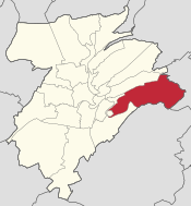
Hamm, Luxembourg
Hamm | |
|---|---|
 Hamm is one of 24 quarters in Luxembourg City | |
| Coordinates: 49°36′25″N 6°10′08″E / 49.607°N 6.169°E | |
| Country | Luxembourg |
| Commune | Luxembourg City |
| Area | |
| • Total | 4.0762 km2 (1.5738 sq mi) |
| Population (31 December 2023)[2] | |
| • Total | 1,569 |
| • Density | 380/km2 (1,000/sq mi) |
| Nationality | |
| • Luxembourgish | 42.26% |
| • Other | 57.74% |
| Website | Hamm |
Hamm (Luxembourgish pronunciation: [hɑm] ) is a quarter in eastern Luxembourg City, in southern Luxembourg. It is the home of the Luxembourg American Cemetery and Memorial, the final resting place of 5,076 American servicemen, including General Patton.[3]
As of 31 December 2023[update], the quarter has a population of 1,569 inhabitants.[2]
Hamm
Hamm | |
|---|---|
| Country | Luxembourg |
| District | Luxembourg |
| Canton | Luxembourg |
| Created | 20 December 1873 |
| Abolished | 26 March 1920 |
| Currently | Part of Luxembourg City |
History
[edit]Hamm's origins lie in the convent of St. Catharine, founded in the 14th century, around which a village developed. The proximity to the Alzette river facilitated the construction of several mills, which formed the basis for spinning and weaving wool from 1835. In the course of the next years, the Godchaux were able to expand their wool production by buying up almost all the mills on the Alzette, which were combined with another factory in Ettelbrück into the „Draperies de Luxembourg“. At their high point, the cloth mills employed up to 2,000 people. Due to the economic boom, Hamm was split off from the commune of Sandweiler in 1873 and received its own administration.
By the law of 20 December 1873, the areas of Hamm, Schleifmühl, Fetschenbour, Haemmerstellgen, Scheidgrund, Scheidhof, Zens, Tavion and Pulvermühl were detached from the commune of Sandweiler and established as the commune of Hamm, with Hamm as its administrative centre.[4]
This change had been driven by the inhabitants of the electoral wards of Hamm, Schleifmühl and Pulvermühl. Initially, after the strong growth of the drapery industry in Schleifmühl around the 1870s when 800 workers were employed by the Godchaux family, residents had addressed a petition to the mayor of Sandweiler, demanding that the above three wards receive an increased number of councilors.[4]
Hamm was a commune in the canton of Luxembourg between 20 December 1873, when it was split from the commune of Sandweiler,[5] and 26 March 1920, when it was merged into the city of Luxembourg, along with Hollerich and Rollingergrund.[6]
Electoral history
[edit]| Election | Mayor | Échevins | |
|---|---|---|---|
| 2 January 1874 | Paul Godchaux | Jean-Pierre Limpach | Jean Jungblut |
| 30 November 1875 | Paul Godchaux | Jean-Pierre Limpach | Victor Conrot |
| 1 December 1881 | Paul Godchaux | Jean-Pierre Limpach | Victor Conrot |
| 28 October 1884 | Paul Godchaux | Mathias Grosber | Victor Conrot |
| 23 April 1889 | Jules Godchaux | Mathias Friderich | Victor Conrot |
| 28 October 1890 | Jules Godchaux | Mathias Friderich | Victor Conrot |
| 28 October 1893 | Jules Godchaux | Jean-Pierre Limpach | Victor Conrot |
Footnotes
[edit]- ^ "Hamm". www.vdl.lu (in French). Ville de Luxembourg. Retrieved 16 June 2018.
- ^ a b c "Statistiques sur la Ville de Luxembourg: Etat de la Population - 2023" (PDF). www.vdl.lu (in French). Ville de Luxembourg. Retrieved 15 October 2024.
- ^ "Luxembourg-Hamm, American Military Cemetery". www.visitluxembourg.com. Archived from the original on 4 April 2019. Retrieved 4 April 2019.
- ^ a b Ney 2009, p. 197.
- ^ (in French)/"Mémorial A, 1873, No. 33" (PDF) (in German). Service central de législation. Archived from the original (PDF) on 15 March 2007. Retrieved 15 August 2006.
- ^ (in French)/"Mémorial A, 1920, No. 23" (PDF) (in German). Service central de législation. Archived from the original (PDF) on 10 April 2008. Retrieved 21 December 2006.
Further reading
[edit]- Ney, Marc (1 April 2009), "Elections dans la commune de Hamm: Depuis sa constitution en 1873 jusqu'à son rattachement à la ville de Luxembourg en 1920", Hémecht (in French), vol. 61, no. 2, retrieved 28 October 2023
49°36′25″N 6°10′08″E / 49.607°N 6.169°E

